The Best Dominican Republic Map!
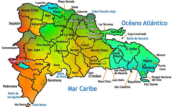
In this page you will find a Dominican Republic map,
Santo Domingo map, Punta Cana map, Sosua and Cabarete
map, Puerto Plata map and many more.
I hope you find the information useful and come
back often to check for updates. I will add more maps
of the Dominican Republic periodically.
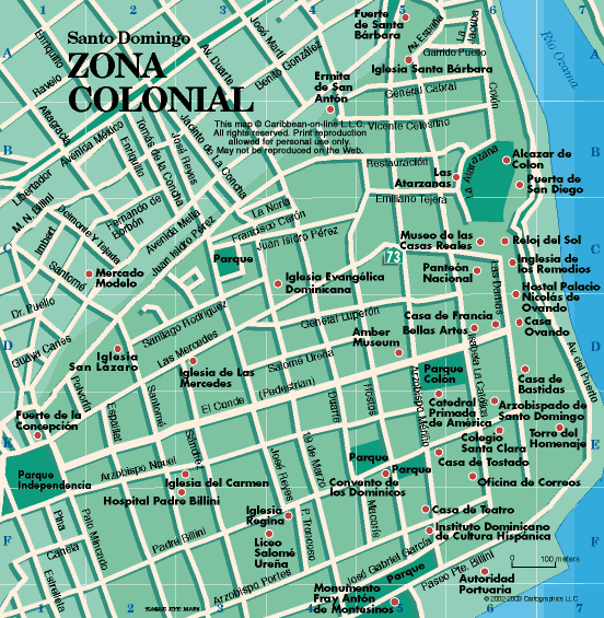
SANTO DOMINGO MAP, COLONIAL ZONE
This is a map of Santo Domingo's Colonial Zone.
Most of the touristic attractions of the area are located here.
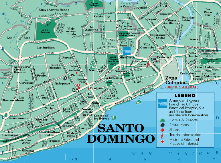
SANTO DOMINGO MAP
Here is a road map of the city of Santo Domingo.
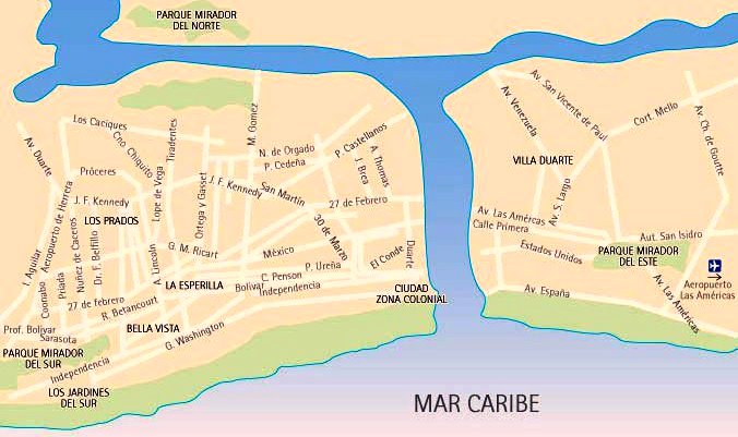
and this is another map of Santo Domingo...
Visiting the Caribbean? Find Deals, Compare Rates,
& Read Hotel Reviews on TripAdvisor
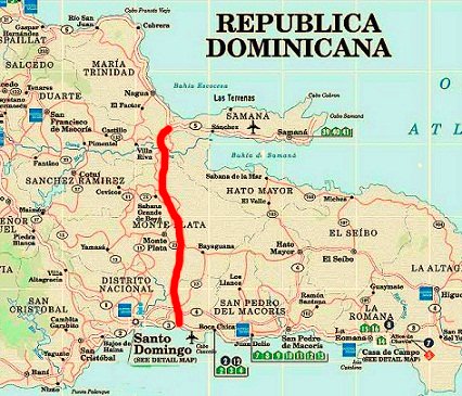
New Highway Santo Domingo - Samana
This Map shows driving directions from Ciudad Colonial,
Santo Domingo to Bavaro Beach Punta Cana.
This is where most resorts are located in Punta Cana.
Dominican Republic Map
Click on View Larger Map to see the detailed directions.
Driving distance from Santo Domingo to:
- Boca Chica: 31 km - 30 min
- La Romana: 110 km - 2 hours
- Punta Cana: 205 km - 3 1/2 hours
- Samana: 245 km - 2 1/2 hours (taking new highway)
- Puerto Plata: 215 km - 3 hours and 15 min
- Las Terrenas: 255 km - 4 hours (taking new highway)
- Barahona: 200 km - 3 1/2 hours
- Santiago 166 km - 3 hours
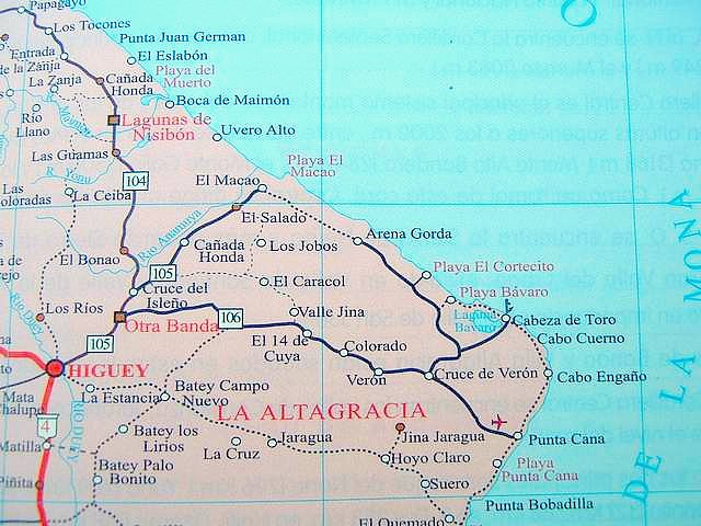
PUNTA CANA MAP
This Punta Cana
Map shows the East Coast of the Dominican Republic.
As you can see
Punta Cana is where the airport is located.
Most of the resorts are in
the Bavaro Beach area.
BAVARO BEACH PUNTA CANA AREA
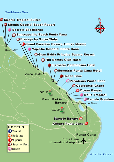
PUNTA CANA RESORT MAP
The Punta Cana area has somewhere around 50 all inclusive resorts. Here you will find their location. Some of the resorts might have changed their name. They are always building new resorts as well.
Go from Dominican Republic Map to
Punta Cana resorts to read reviews!
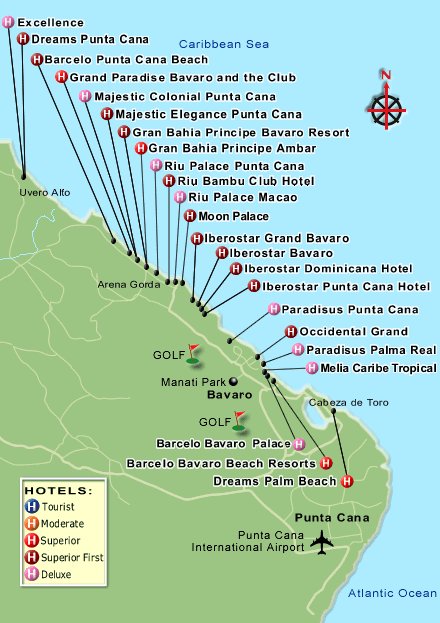
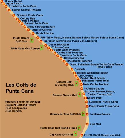
PUNTA CANA RESORTS AND GOLF COURSES
This is a more updated Punta Cana Resort Map.
You can also see the Golf Courses available in this area.
Driving distance from Punta Cana to:
- Higuey: 60 km - 1 hour
- Boca Chica: 169 km - 3 hours
- Puerto Plata: 425 km - 7 hours and 45 minutes
- Samana: 185 km - 3 1/2 hours
- La Romana: 105 km - 2 hours
SOSUA AND CABARETE MAP
Sosua and Cabarete
are on the North Coast of the Dominican Republic.
Puerto Plata's
airport is the closest to Sosua and Cabarete.
Puerto Plata is located
west of these two locations.
SOSUA MAP
CABARETE MAP
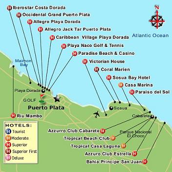
This map shows the resorts on the North Coast of Dominican Republic. Driving distance from Puerto Plata to: Do you have a great Punta Cana Resort Map you would like to see on this page? Submit it! Return to Home Page
All content (including text, photographs and video) is copyrighted.
View Larger Map
PUERTO PLATA, SOSUA AND CABARETE RESORT MAP
The area of Puerto Plata, Sosua and Cabarete.
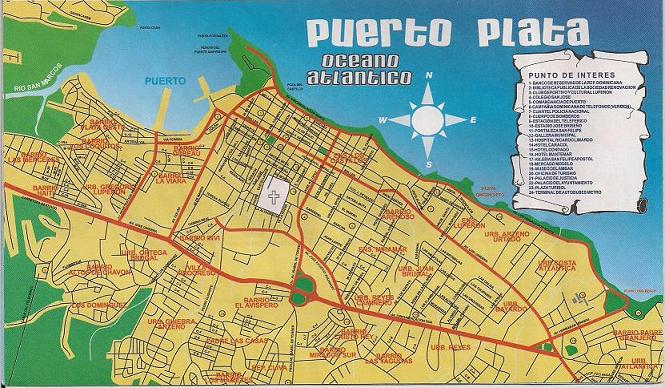
PUERTO PLATA MAP
Have a Dominican Republic Map
you would like to share?
Go from Dominican Republic Map to Beaches
Go to Dominican Republic Music




New! Comments
Have your say about what you just read! Leave me a comment in the box below.